 01
Shaar Waterfall
Shaar Waterfall, also known as Bash-Kaindy, is one of the largest waterfalls in Central Asia: a 220 m drop, about 400 m with its cascades, at around 3,100-3,500 m in the At-Bashy district of the Naryn region. The road ends at the village of Bash-Kaindy; the waterfall is a further 11.5 km on foot up the valley with river fords, half a day each way. Summer only.
 02
33 Parrots Waterfall
The 33 Parrots Waterfall is a mountain waterfall about 30 m high at around 2,600 m in the Naryn region, near Son-Kul Lake, with one of the most memorable local names in the country.
 03
Chech-Dobo Valley
Chech-Dobo is a high valley in the At-Bashy district with open pastures and a sacred site of seven springs where people have come to pray since pre-Islamic times. Only two herding families live nearby.
 04
Kuldzha-Bashi Canyon
Kuldzha-Bashi is a miniature canyon in the Ak-Say valley of the At-Bashy district, at about 3,500 m on the way to Kel-Suu Lake. Over 1-2 km a small river has cut bizarre rock towers out of soft ground, with a modest waterfall halfway along.
 05
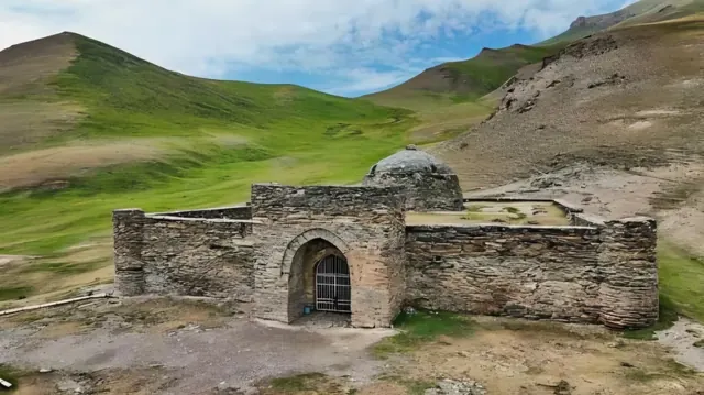
Tash-Rabat Caravanserai
Tash-Rabat is a stone caravanserai of 31 rooms in a remote valley of the At-Bashy district at over 3,200 m. Its dating is debated: the UNESCO tentative list entry places it in the 11th-12th centuries, other researchers date it to the 10th or the 15th century. A Silk Road building that needs no set dressing.
UNESCO Tentative List: Silk Roads Sites in Kyrgyzstan (2010) ↗
 06
Ara-Kol Lake
Ara-Kol is a small brackish lake at about 2,000 m in open farmland of the Kochkor district, 21 km west of Kochkor and about 3.5-4.5 hours from Bishkek by road. In January it freezes solid with 50-60 cm of clear ice full of cracks and bubbles: the country's largest natural skating rink, with horses and cars driven on the ice. No infrastructure on site.
 07
Kel-Suu Lake
Kel-Suu is a long lake in the At-Bashy district near the Chinese border, flooding a canyon with sheer rock walls, about 150 km from Naryn. It lies in the border zone: a permit takes up to six days, vehicle access to the shore is restricted and visits are only possible with organised groups, so the shoot is planned in advance.
 08
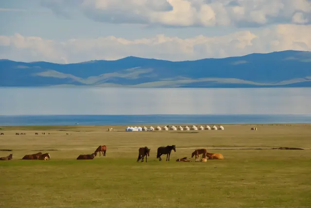
Son-Kul Lake
Son-Kul (also spelled Song-Kul) is a high plateau lake at about 3,000 m, surrounded by summer pastures where herders set up yurts. The classic image of nomadic Kyrgyzstan.
 09
Chatyr-Kul Lake
Chatyr-Kul is a high-altitude lake at about 3,500 m, 23 by 11 km, near the Torugart Pass and the Chinese border; the Naryn-Torugart road runs along its shore. Stark, empty and other-worldly; it lies in the border zone and needs a pass.
 10
Kekemeren River
The Kekemeren River runs through a deep valley with red and grey slopes, one of the most varied river landscapes in the centre of Kyrgyzstan.
 11
Naryn River
The Naryn River is the longest river in Kyrgyzstan, 807 km, and the main headwater of the Syr Darya. It cuts through canyons and wide valleys and is used for rafting of every grade.
 12
Kara-Keche Gorge
Kara-Keche in the Jumgal district is the largest coal deposit in Kyrgyzstan: an open-pit mine and haul roads over high passes in the mountains near Son-Kul, an industrial landscape in the middle of nomad country.
 13
Eki-Naryn Gorge
Eki-Naryn ('Two Naryns') is the valley where the Big and Small Naryn rivers meet, 45 km east of the city of Naryn by a gravel and asphalt road, at 2,000-2,260 m inside the Salkyn-Tor nature park: spruce forest, alpine meadows, yurts in summer and maral deer in the park. The location is right by the road.
Approximate figures by road from the centre of Bishkek, without stops; mountain roads and weather change the time. * to the nearest road, the location itself is reached on foot, by horse or by 4x4 track. We confirm the logistics for each project in the production plan.