 01
Issyk-Kul Lake
Issyk-Kul Lake lies at 1,607 m, is about 180 km long and does not freeze in winter. Endless water with snow-capped ridges on both shores: on screen it reads as a sea.
Issyk-Kul region surrounds the lake of the same name, one of the largest alpine lakes in the world, set between the ridges of the Tian Shan. Sand beaches, red sandstone canyons, glacial lakes, hot springs and the town of Karakol make it the most varied region for filming in Kyrgyzstan.
On screen it can double for a sea coast, red canyons of the American Southwest, Alpine ski towns and glacial lakes.
01Issyk-Kul Lake lies at 1,607 m, is about 180 km long and does not freeze in winter. Endless water with snow-capped ridges on both shores: on screen it reads as a sea.
 02
Barskoon Gorge on the south shore of Issyk-Kul holds several waterfalls: the main 24 m fall is the best known, and the Big Barskoon drops more than 60 m.
 03
Enilchek is a remote former mining town in the far east of the region, on the way to the Inylchek Glacier. Most of its Soviet apartment blocks stand empty next to a small village that is still inhabited; the road from Karakol is long and can close in winter.
 04
Jyrgalan Valley, east of Karakol, combines alpine meadows, spruce forests and a small former mining village.
 05
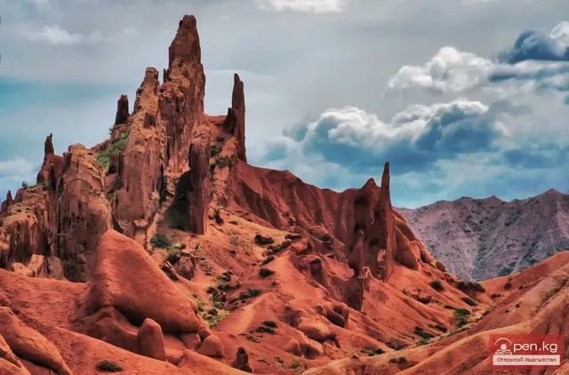
Skazka ('Fairy Tale') Canyon near the village of Tosor on the south shore of Issyk-Kul is a maze of eroded red clay and sandstone formations, including the ridge known as the 'Chinese Wall', minutes from the lake.
 06
Ak-Say, the 'canyons of forgotten rivers', are little-known bright red clay canyons on the south shore of Issyk-Kul near Bokonbaevo: desert and western scenes minutes from the lake.
 07
Karakol Gorge starts at the town of Karakol, the main base in the east of Issyk-Kul: spruce forest, a fast river and alpine meadows leading up to high peaks.
 08
Ala-Kul is a turquoise glacial lake at about 3,500 m above Karakol, reached by a trek. One of the most striking high-mountain locations in Kyrgyzstan.
 09
Suttu-Bulak, the 'milk spring' lake, sits at about 2,700 m in the Semenovka Gorge on the north shore of Issyk-Kul. It was formed by a landslide after the earthquake of 1910-1911; the water is about 20 m deep with a milky bluish tint, and 4x4 vehicles can reach the shore.
 10
Issyk-Kul beaches: wide sand, clear water and mountains in the background. A seaside setting in the middle of Central Asia.
 11
Altyn-Arashan is a mountain valley with hot springs at about 2,500 m near Karakol, beneath spruce forest and peaks. The paved road ends at the village of Ak-Suu, 12 km from Karakol; the valley is a further 12-15 km by rough 4x4 track (2-3 hours in a UAZ) or on foot.
 12
Jeti-Oguz Gorge near Karakol stretches 37 km from about 2,200 m, known for the red sandstone cliffs of the 'Seven Bulls' and the 'Broken Heart' rock, both protected natural monuments. Red rock against green slopes and snow.
 13
Kyrchyn Gorge on the north shore of Issyk-Kul hosted the ethnic village of the World Nomad Games: open alpine meadows suited to yurts, horse scenes and large crowds.
| Location | By road | Drive time |
|---|---|---|
| Issyk-Kul Lake | ~187 km | ~3 h |
| Barskoon Waterfall | ~346 km | ~5 h |
| Enilchek Town | ~565 km | ~11 h |
| Jyrgalan Valley | ~449 km | ~9 h |
| Skazka Canyon | ~307 km | ~5 h |
| Ak-Say Canyons | ~274 km | ~4 h |
| Karakol | ~407 km | ~7 h |
| Ala-Kul Lake | ~407 km | ~7 h |
| Suttu-Bulak Lake | ~306 km | ~5 h |
| Issyk-Kul Beach | ~264 km | ~4 h |
| Altyn-Arashan River | ~415 km * | ~7 h |
| Jeti-Oguz Gorge | ~402 km | ~7 h |
| Kyrchyn Gorge | ~305 km | ~5 h |
Approximate figures by road from the centre of Bishkek, without stops; mountain roads and weather change the time. * to the nearest road, the location itself is reached on foot, by horse or by 4x4 track. We confirm the logistics for each project in the production plan.
We can run a location scout specifically for your script.
Updated: 2026-10-20